

Platform Capabilities
Infrastructure intelligence for field execution.
OcuBuild Technologies Inc. develops infrastructure intelligence systems that connect BIM, CAD, field data, and operational workflows to the physical environments where construction and infrastructure teams execute.
Our core platform, OcuCore, maintains alignment between physical reality, engineered geometry, and operational information while extending existing systems such as Procore, Autodesk Construction Cloud, Revit, and Navisworks.
Federal Identifiers
Registered and ready to engage.
Platform Architecture
Reality. Geometry. Information.
OcuCore is the operational intelligence layer connecting the physical jobsite, coordinated digital models, and the structured information teams need to make field decisions.
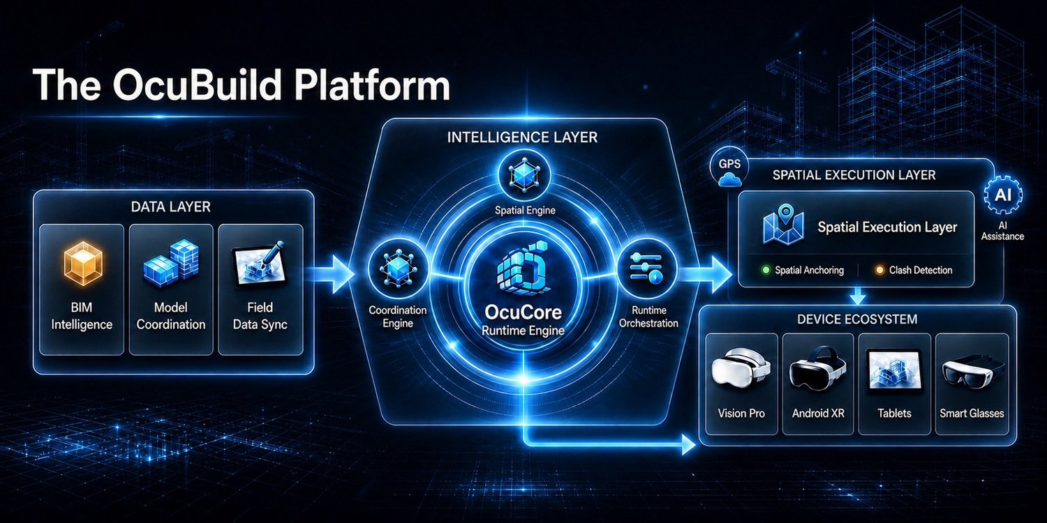
OcuCore Runtime
Infrastructure intelligence connected to the work.
Physical environment
The jobsite, facility, infrastructure asset, and installed conditions where work is actually performed.
Engineered model
BIM, CAD, coordinated system geometry, discipline-specific data, and spatial reference information.
Operational context
Field annotations, verification records, system attributes, coordination notes, and execution intelligence.
Core Capabilities
Designed to improve field clarity, coordination, and verification.
BIM-to-Field Spatial Verification
Connect coordinated digital geometry to physical conditions so field teams can verify installation intent where the work happens.
Digital Engineering Integration
Extends BIM and CAD workflows with discipline-aware field access to coordinated electrical, mechanical, low-voltage, life-safety, and related systems.
Field Coordination & Decision Capture
Preserves field observations, verification information, and coordination context so decisions remain connected to physical conditions.
Offline-First Field Execution
Supports operational workflows where connectivity may be limited, intermittent, restricted, or unavailable.
Spatial Runtime Engineering
Maintains the relationship between physical environments, engineered geometry, spatial references, and operational information.
Multi-Device Deployment
Designed for spatial-computing and field-device environments without locking operations to a single hardware ecosystem.
Differentiators
Built around operational value in the field.
OcuBuild is designed around real infrastructure execution rather than adapting consumer XR concepts to construction. The platform focuses on increasing confidence, reducing coordination ambiguity, and keeping digital information connected to physical work.
- Field-Validated Execution Designed around real jobsite workflows to reduce coordination ambiguity and improve field adoption.
- Persistent Spatial Trust Maintains alignment between digital models and physical conditions to improve confidence in field verification.
- Works With Existing Systems Extends Procore, Autodesk Construction Cloud, Revit, Navisworks, and established coordination workflows rather than replacing them.
- Offline-First Operations Supports field execution where connectivity is limited, intermittent, or restricted.
- Cross-Platform Architecture Designed for multiple spatial-computing and field-device environments, reducing dependence on a single hardware ecosystem.
NAICS
Federal capability alignment.
OcuBuild's federal positioning centers on software development, systems design, research and development, engineering, and technology-enabled infrastructure execution.
NAICS Codes
Capability Statement
Federal and prime contractor materials.
Download OcuBuild's capability statement for government contracting, prime contractor, research, infrastructure modernization, and strategic partnership discussions.
Federal & Prime Contractor Inquiries
Samuel Lovett · Founder & CEO
Next Step
Start with the operational problem.
OcuBuild works with contractors, infrastructure organizations, research partners, and government stakeholders exploring better ways to connect digital engineering information with field execution.
OcuBuild Technologies Inc. develops infrastructure intelligence technology for BIM-to-field spatial verification, digital engineering integration, field coordination, offline-first execution, spatial computing, infrastructure modernization, government contracting, construction technology, mission-critical infrastructure, UEI EL8XSJX3LN57, CAGE 20UB0, and SAM.gov registered federal readiness.